|
|
|||||||||||||||||
| Point ID: 7872 | Downloads | Plots | Site Data | Code: 3341 |
|
|
|||||||||||||||||
| Download | |
|---|---|
| Site Descriptor Information | Site Time Series Data |
| Link to all available data | |
| View: | Time Series | All |
| Units: | m3/s |
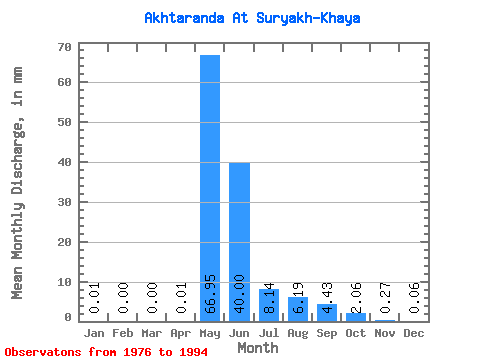
| Statistic | Jan | Feb | Mar | Apr | May | Jun | Jul | Aug | Sep | Oct | Nov | Dec | Annual |
|---|---|---|---|---|---|---|---|---|---|---|---|---|---|
| Mean | 0.01 | 0.00 | 0.00 | 0.01 | 66.94 | 40.00 | 8.14 | 6.19 | 4.43 | 2.06 | 0.27 | 0.06 | 117.48 |
| Standard Deviation | 0.01 | 0.00 | 0.00 | 0.03 | 31.47 | 26.13 | 10.15 | 10.92 | 5.12 | 2.42 | 0.32 | 0.06 | 39.17 |
| Min | 0.00 | 0.00 | 0.00 | 0.00 | 25.39 | 7.40 | 1.57 | 0.19 | 0.10 | 0.12 | 0.03 | 0.00 | 42.66 |
| Max | 0.04 | 0.01 | 0.00 | 0.10 | 131.13 | 77.76 | 40.86 | 41.09 | 14.55 | 7.94 | 1.27 | 0.23 | 169.80 |
| Coefficient of Variation | 0.93 | 2.00 | 3.32 | 2.67 | 0.47 | 0.65 | 1.25 | 1.76 | 1.16 | 1.17 | 1.21 | 1.09 | 0.33 |
 Return to R-Arctic Net Home Page