|
|
|||||||||||||||||
| Point ID: 7867 | Downloads | Plots | Site Data | Code: 3336 |
|
|
|||||||||||||||||
| Download | |
|---|---|
| Site Descriptor Information | Site Time Series Data |
| Link to all available data | |
| View: | Time Series | All |
| Units: | mm |
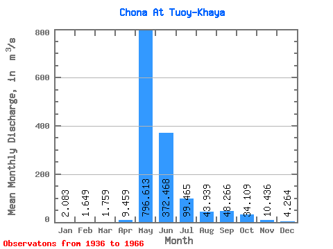
| Statistic | Jan | Feb | Mar | Apr | May | Jun | Jul | Aug | Sep | Oct | Nov | Dec | Annual |
|---|---|---|---|---|---|---|---|---|---|---|---|---|---|
| Mean | 2.08 | 1.65 | 1.76 | 9.46 | 796.61 | 372.47 | 99.47 | 43.94 | 48.27 | 34.11 | 10.44 | 4.26 | 118.71 |
| Standard Deviation | 0.88 | 0.76 | 1.17 | 27.28 | 282.65 | 268.77 | 68.39 | 43.18 | 37.88 | 21.49 | 5.88 | 2.47 | 38.28 |
| Min | 0.21 | 0.05 | 0.38 | 0.36 | 324.00 | 85.40 | 28.80 | 13.50 | 8.75 | 6.02 | 3.19 | 1.62 | 47.97 |
| Max | 4.64 | 3.63 | 6.08 | 150.00 | 1360.00 | 1440.00 | 292.00 | 236.00 | 150.00 | 91.90 | 33.10 | 13.80 | 192.02 |
| Coefficient of Variation | 0.42 | 0.46 | 0.66 | 2.88 | 0.35 | 0.72 | 0.69 | 0.98 | 0.79 | 0.63 | 0.56 | 0.58 | 0.32 |
 Return to R-Arctic Net Home Page