|
|
|||||||||||||||||
| Point ID: 7867 | Downloads | Plots | Site Data | Code: 3336 |
|
|
|||||||||||||||||
| Download | |
|---|---|
| Site Descriptor Information | Site Time Series Data |
| Link to all available data | |
| View: | Time Series | All |
| Units: | m3/s |
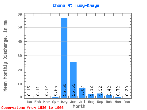
| Statistic | Jan | Feb | Mar | Apr | May | Jun | Jul | Aug | Sep | Oct | Nov | Dec | Annual |
|---|---|---|---|---|---|---|---|---|---|---|---|---|---|
| Mean | 0.15 | 0.11 | 0.12 | 0.65 | 56.59 | 25.61 | 7.07 | 3.12 | 3.32 | 2.42 | 0.72 | 0.30 | 99.38 |
| Standard Deviation | 0.06 | 0.05 | 0.08 | 1.88 | 20.08 | 18.48 | 4.86 | 3.07 | 2.60 | 1.53 | 0.40 | 0.18 | 32.05 |
| Min | 0.01 | 0.00 | 0.03 | 0.03 | 23.02 | 5.87 | 2.05 | 0.96 | 0.60 | 0.43 | 0.22 | 0.12 | 40.16 |
| Max | 0.33 | 0.23 | 0.43 | 10.31 | 96.61 | 99.00 | 20.74 | 16.76 | 10.31 | 6.53 | 2.28 | 0.98 | 160.74 |
| Coefficient of Variation | 0.42 | 0.46 | 0.66 | 2.88 | 0.35 | 0.72 | 0.69 | 0.98 | 0.79 | 0.63 | 0.56 | 0.58 | 0.32 |
 Return to R-Arctic Net Home Page