|
|
|||||||||||||||||
| Point ID: 7866 | Downloads | Plots | Site Data | Code: 3333 |
|
|
|||||||||||||||||
| Download | |
|---|---|
| Site Descriptor Information | Site Time Series Data |
| Link to all available data | |
| View: | Time Series | All |
| Units: | mm |
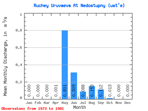
| Statistic | Jan | Feb | Mar | Apr | May | Jun | Jul | Aug | Sep | Oct | Nov | Dec | Annual |
|---|---|---|---|---|---|---|---|---|---|---|---|---|---|
| Mean | 0.00 | 0.00 | 0.00 | 0.00 | 0.80 | 0.31 | 0.09 | 0.15 | 0.11 | 0.01 | 0.00 | 0.00 | 0.12 |
| Standard Deviation | 0.00 | 0.00 | 0.00 | 0.00 | 0.25 | 0.19 | 0.15 | 0.21 | 0.11 | 0.01 | 0.00 | 0.00 | 0.04 |
| Min | 0.00 | 0.00 | 0.00 | 0.00 | 0.48 | 0.09 | 0.00 | 0.00 | 0.00 | 0.00 | 0.00 | 0.00 | 0.06 |
| Max | 0.00 | 0.00 | 0.00 | 0.01 | 1.32 | 0.60 | 0.47 | 0.59 | 0.30 | 0.03 | 0.00 | 0.00 | 0.18 |
| Coefficient of Variation | 3.00 | 0.31 | 0.62 | 1.75 | 1.34 | 0.99 | 1.00 | 0.31 |
 Return to R-Arctic Net Home Page