|
|
|||||||||||||||||
| Point ID: 7866 | Downloads | Plots | Site Data | Code: 3333 |
|
|
|||||||||||||||||
| Download | |
|---|---|
| Site Descriptor Information | Site Time Series Data |
| Link to all available data | |
| View: | Time Series | All |
| Units: | m3/s |
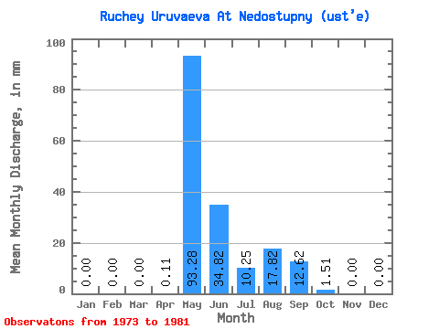
| Statistic | Jan | Feb | Mar | Apr | May | Jun | Jul | Aug | Sep | Oct | Nov | Dec | Annual |
|---|---|---|---|---|---|---|---|---|---|---|---|---|---|
| Mean | 0.00 | 0.00 | 0.00 | 0.06 | 93.29 | 34.87 | 10.29 | 17.84 | 12.66 | 1.51 | 0.00 | 0.00 | 169.02 |
| Standard Deviation | 0.00 | 0.00 | 0.00 | 0.19 | 29.23 | 21.63 | 18.04 | 23.94 | 12.54 | 1.51 | 0.00 | 0.00 | 52.78 |
| Min | 0.00 | 0.00 | 0.00 | 0.00 | 55.89 | 9.58 | 0.12 | 0.00 | 0.00 | 0.00 | 0.00 | 0.00 | 77.41 |
| Max | 0.00 | 0.00 | 0.00 | 0.56 | 153.69 | 67.62 | 54.72 | 68.70 | 33.81 | 3.73 | 0.00 | 0.00 | 254.19 |
| Coefficient of Variation | 3.00 | 0.31 | 0.62 | 1.75 | 1.34 | 0.99 | 1.00 | 0.31 |
 Return to R-Arctic Net Home Page