|
|
|||||||||||||||||
| Point ID: 7850 | Downloads | Plots | Site Data | Code: 3261 |
|
|
|||||||||||||||||
| Download | |
|---|---|
| Site Descriptor Information | Site Time Series Data |
| Link to all available data | |
| View: | Time Series | All |
| Units: | mm |
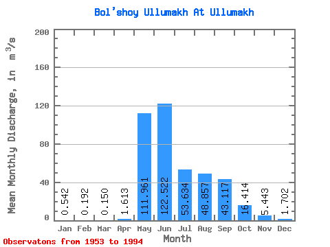
| Statistic | Jan | Feb | Mar | Apr | May | Jun | Jul | Aug | Sep | Oct | Nov | Dec | Annual |
|---|---|---|---|---|---|---|---|---|---|---|---|---|---|
| Mean | 0.54 | 0.19 | 0.15 | 1.61 | 111.96 | 122.52 | 53.63 | 48.86 | 43.12 | 16.41 | 5.44 | 1.70 | 35.03 |
| Standard Deviation | 0.94 | 0.63 | 0.68 | 2.38 | 41.25 | 65.00 | 33.91 | 30.27 | 23.48 | 7.78 | 3.97 | 1.90 | 7.62 |
| Min | 0.00 | 0.00 | 0.00 | 0.00 | 22.10 | 37.50 | 8.48 | 9.23 | 13.30 | 6.40 | 0.45 | 0.00 | 23.93 |
| Max | 4.26 | 3.55 | 3.91 | 12.20 | 195.00 | 286.00 | 154.00 | 110.00 | 108.00 | 35.20 | 22.30 | 8.06 | 50.73 |
| Coefficient of Variation | 1.74 | 3.27 | 4.53 | 1.47 | 0.37 | 0.53 | 0.63 | 0.62 | 0.55 | 0.47 | 0.73 | 1.12 | 0.22 |
 Return to R-Arctic Net Home Page