|
|
|||||||||||||||||
| Point ID: 7850 | Downloads | Plots | Site Data | Code: 3261 |
|
|
|||||||||||||||||
| Download | |
|---|---|
| Site Descriptor Information | Site Time Series Data |
| Link to all available data | |
| View: | Time Series | All |
| Units: | m3/s |
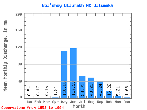
| Statistic | Jan | Feb | Mar | Apr | May | Jun | Jul | Aug | Sep | Oct | Nov | Dec | Annual |
|---|---|---|---|---|---|---|---|---|---|---|---|---|---|
| Mean | 0.54 | 0.17 | 0.15 | 1.54 | 110.64 | 117.19 | 53.00 | 48.28 | 41.24 | 16.22 | 5.21 | 1.68 | 407.96 |
| Standard Deviation | 0.93 | 0.57 | 0.67 | 2.27 | 40.76 | 62.17 | 33.51 | 29.91 | 22.46 | 7.69 | 3.80 | 1.88 | 88.79 |
| Min | 0.00 | 0.00 | 0.00 | 0.00 | 21.84 | 35.87 | 8.38 | 9.12 | 12.72 | 6.32 | 0.43 | 0.00 | 278.62 |
| Max | 4.21 | 3.20 | 3.86 | 11.67 | 192.70 | 273.55 | 152.18 | 108.70 | 103.30 | 34.78 | 21.33 | 7.96 | 590.75 |
| Coefficient of Variation | 1.74 | 3.27 | 4.53 | 1.47 | 0.37 | 0.53 | 0.63 | 0.62 | 0.55 | 0.47 | 0.73 | 1.12 | 0.22 |
 Return to R-Arctic Net Home Page