|
|
|||||||||||||||||
| Point ID: 7849 | Downloads | Plots | Site Data | Code: 3260 |
|
|
|||||||||||||||||
| Download | |
|---|---|
| Site Descriptor Information | Site Time Series Data |
| Link to all available data | |
| View: | Time Series | All |
| Units: | mm |
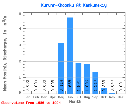
| Statistic | Jan | Feb | Mar | Apr | May | Jun | Jul | Aug | Sep | Oct | Nov | Dec | Annual |
|---|---|---|---|---|---|---|---|---|---|---|---|---|---|
| Mean | 0.00 | 0.00 | 0.00 | 0.01 | 3.11 | 4.69 | 1.89 | 1.84 | 1.32 | 0.37 | 0.05 | 0.00 | 1.18 |
| Standard Deviation | 0.00 | 0.00 | 0.00 | 0.01 | 2.28 | 2.54 | 1.19 | 1.29 | 0.60 | 0.19 | 0.03 | 0.00 | 0.13 |
| Min | 0.00 | 0.00 | 0.00 | 0.00 | 0.16 | 1.19 | 0.42 | 0.45 | 0.44 | 0.11 | 0.00 | 0.00 | 1.06 |
| Max | 0.00 | 0.00 | 0.00 | 0.03 | 9.17 | 8.42 | 5.10 | 4.76 | 2.33 | 0.68 | 0.11 | 0.01 | 1.42 |
| Coefficient of Variation | 0.99 | 0.73 | 0.54 | 0.63 | 0.70 | 0.46 | 0.51 | 0.70 | 2.41 | 0.11 |
 Return to R-Arctic Net Home Page