|
|
|||||||||||||||||
| Point ID: 7849 | Downloads | Plots | Site Data | Code: 3260 |
|
|
|||||||||||||||||
| Download | |
|---|---|
| Site Descriptor Information | Site Time Series Data |
| Link to all available data | |
| View: | Time Series | All |
| Units: | m3/s |
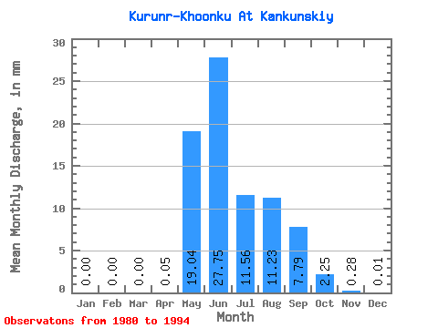
| Statistic | Jan | Feb | Mar | Apr | May | Jun | Jul | Aug | Sep | Oct | Nov | Dec | Annual |
|---|---|---|---|---|---|---|---|---|---|---|---|---|---|
| Mean | 0.00 | 0.00 | 0.00 | 0.05 | 19.04 | 27.75 | 11.56 | 11.22 | 7.79 | 2.25 | 0.28 | 0.01 | 84.92 |
| Standard Deviation | 0.00 | 0.00 | 0.00 | 0.05 | 13.93 | 15.02 | 7.28 | 7.89 | 3.56 | 1.14 | 0.19 | 0.02 | 9.34 |
| Min | 0.00 | 0.00 | 0.00 | 0.00 | 0.98 | 7.04 | 2.57 | 2.75 | 2.60 | 0.67 | 0.00 | 0.00 | 76.59 |
| Max | 0.00 | 0.00 | 0.00 | 0.15 | 56.07 | 49.83 | 31.18 | 29.10 | 13.79 | 4.16 | 0.65 | 0.06 | 102.44 |
| Coefficient of Variation | 0.99 | 0.73 | 0.54 | 0.63 | 0.70 | 0.46 | 0.51 | 0.70 | 2.41 | 0.11 |
 Return to R-Arctic Net Home Page