|
|
|||||||||||||||||
| Point ID: 784 | Downloads | Plots | Site Data | Code: 07HC002 |
|
|
|||||||||||||||||
| Download | |
|---|---|
| Site Descriptor Information | Site Time Series Data |
| Link to all available data | |
| View: | Time Series | All |
| Units: | mm |
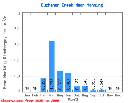
| Statistic | Jan | Feb | Mar | Apr | May | Jun | Jul | Aug | Sep | Oct | Nov | Dec | Annual |
|---|---|---|---|---|---|---|---|---|---|---|---|---|---|
| Mean | 0.34 | 1.27 | 0.53 | 0.48 | 0.14 | 0.15 | 0.04 | 0.04 | |||||
| Standard Deviation | 0.63 | 1.13 | 0.80 | 0.95 | 0.25 | 0.43 | 0.09 | 0.12 | |||||
| Min | 0.00 | 0.01 | 0.00 | 0.00 | 0.00 | 0.00 | 0.00 | 0.00 | |||||
| Max | 2.23 | 4.30 | 3.07 | 3.57 | 0.97 | 1.71 | 0.35 | 0.45 | |||||
| Coefficient of Variation | 1.87 | 0.89 | 1.50 | 1.96 | 1.80 | 2.92 | 2.37 | 2.70 |
 Return to R-Arctic Net Home Page