|
|
|||||||||||||||||
| Point ID: 784 | Downloads | Plots | Site Data | Code: 07HC002 |
|
|
|||||||||||||||||
| Download | |
|---|---|
| Site Descriptor Information | Site Time Series Data |
| Link to all available data | |
| View: | Time Series | All |
| Units: | m3/s |
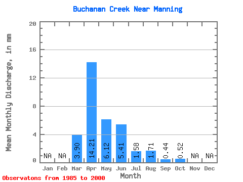
| Statistic | Jan | Feb | Mar | Apr | May | Jun | Jul | Aug | Sep | Oct | Nov | Dec | Annual |
|---|---|---|---|---|---|---|---|---|---|---|---|---|---|
| Mean | 3.91 | 14.22 | 6.12 | 5.41 | 1.58 | 1.71 | 0.43 | 0.52 | |||||
| Standard Deviation | 7.29 | 12.58 | 9.19 | 10.57 | 2.84 | 5.00 | 1.02 | 1.39 | |||||
| Min | 0.00 | 0.06 | 0.00 | 0.00 | 0.00 | 0.00 | 0.00 | 0.00 | |||||
| Max | 25.74 | 48.04 | 35.44 | 39.89 | 11.22 | 19.74 | 3.92 | 5.15 | |||||
| Coefficient of Variation | 1.87 | 0.89 | 1.50 | 1.96 | 1.80 | 2.92 | 2.37 | 2.70 |
 Return to R-Arctic Net Home Page