|
|
|||||||||||||||||
| Point ID: 7825 | Downloads | Plots | Site Data | Code: 3189 |
|
|
|||||||||||||||||
| Download | |
|---|---|
| Site Descriptor Information | Site Time Series Data |
| Link to all available data | |
| View: | Time Series | All |
| Units: | mm |
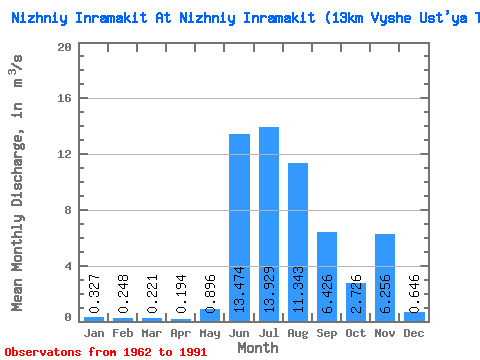
| Statistic | Jan | Feb | Mar | Apr | May | Jun | Jul | Aug | Sep | Oct | Nov | Dec | Annual |
|---|---|---|---|---|---|---|---|---|---|---|---|---|---|
| Mean | 0.33 | 0.25 | 0.22 | 0.19 | 0.90 | 13.47 | 13.93 | 11.34 | 6.43 | 2.73 | 6.26 | 0.65 | 4.45 |
| Standard Deviation | 0.49 | 0.38 | 0.35 | 0.31 | 2.02 | 7.41 | 5.95 | 7.82 | 2.25 | 0.65 | 22.17 | 0.56 | 1.45 |
| Min | 0.00 | 0.00 | 0.00 | 0.00 | 0.00 | 0.06 | 4.38 | 3.97 | 3.93 | 1.32 | 0.71 | 0.00 | 1.68 |
| Max | 1.28 | 0.91 | 0.82 | 0.74 | 8.15 | 29.60 | 28.50 | 40.70 | 12.00 | 3.67 | 103.00 | 1.60 | 7.86 |
| Coefficient of Variation | 1.50 | 1.54 | 1.57 | 1.58 | 2.26 | 0.55 | 0.43 | 0.69 | 0.35 | 0.24 | 3.54 | 0.86 | 0.33 |
 Return to R-Arctic Net Home Page