|
|
|||||||||||||||||
| Point ID: 7825 | Downloads | Plots | Site Data | Code: 3189 |
|
|
|||||||||||||||||
| Download | |
|---|---|
| Site Descriptor Information | Site Time Series Data |
| Link to all available data | |
| View: | Time Series | All |
| Units: | m3/s |
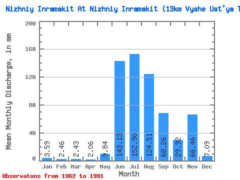
| Statistic | Jan | Feb | Mar | Apr | May | Jun | Jul | Aug | Sep | Oct | Nov | Dec | Annual |
|---|---|---|---|---|---|---|---|---|---|---|---|---|---|
| Mean | 3.59 | 2.48 | 2.42 | 2.06 | 9.83 | 143.14 | 152.87 | 124.49 | 68.26 | 29.92 | 66.46 | 7.09 | 575.94 |
| Standard Deviation | 5.39 | 3.80 | 3.80 | 3.25 | 22.20 | 78.74 | 65.27 | 85.78 | 23.86 | 7.08 | 235.54 | 6.13 | 187.62 |
| Min | 0.00 | 0.00 | 0.00 | 0.00 | 0.00 | 0.64 | 48.07 | 43.57 | 41.75 | 14.49 | 7.54 | 0.00 | 217.59 |
| Max | 14.05 | 9.10 | 9.00 | 7.86 | 89.45 | 314.44 | 312.80 | 446.70 | 127.47 | 40.28 | 1094.17 | 17.56 | 1016.97 |
| Coefficient of Variation | 1.50 | 1.54 | 1.57 | 1.58 | 2.26 | 0.55 | 0.43 | 0.69 | 0.35 | 0.24 | 3.54 | 0.86 | 0.33 |
 Return to R-Arctic Net Home Page