|
|
|||||||||||||||||
| Point ID: 7735 | Downloads | Plots | Site Data | Code: Ru001 |
|
|
|||||||||||||||||
| Download | |
|---|---|
| Site Descriptor Information | Site Time Series Data |
| Link to all available data | |
| View: | Time Series | All |
| Units: | mm |
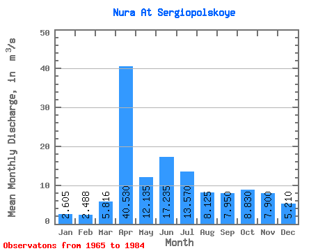
| Statistic | Jan | Feb | Mar | Apr | May | Jun | Jul | Aug | Sep | Oct | Nov | Dec | Annual |
|---|---|---|---|---|---|---|---|---|---|---|---|---|---|
| Mean | 2.60 | 2.49 | 5.82 | 40.53 | 12.13 | 17.23 | 13.57 | 8.12 | 7.95 | 8.83 | 7.90 | 5.21 | 11.42 |
| Standard Deviation | 7.22 | 7.42 | 6.00 | 37.64 | 33.90 | 52.20 | 28.98 | 9.93 | 9.01 | 13.50 | 13.87 | 12.40 | 18.36 |
| Min | 0.00 | 0.00 | 0.00 | 2.00 | 1.00 | 0.00 | 0.00 | 0.00 | 0.00 | 0.00 | 0.00 | 0.00 | 0.42 |
| Max | 33.00 | 32.00 | 20.00 | 134.00 | 155.00 | 238.00 | 134.00 | 41.00 | 35.50 | 61.50 | 64.00 | 57.00 | 83.32 |
| Coefficient of Variation | 2.77 | 2.98 | 1.03 | 0.93 | 2.79 | 3.03 | 2.13 | 1.22 | 1.13 | 1.53 | 1.75 | 2.38 | 1.61 |
 Return to R-Arctic Net Home Page