|
|
|||||||||||||||||
| Point ID: 7735 | Downloads | Plots | Site Data | Code: Ru001 |
|
|
|||||||||||||||||
| Download | |
|---|---|
| Site Descriptor Information | Site Time Series Data |
| Link to all available data | |
| View: | Time Series | All |
| Units: | m3/s |
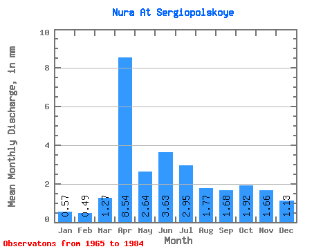
| Statistic | Jan | Feb | Mar | Apr | May | Jun | Jul | Aug | Sep | Oct | Nov | Dec | Annual |
|---|---|---|---|---|---|---|---|---|---|---|---|---|---|
| Mean | 0.57 | 0.49 | 1.27 | 8.54 | 2.64 | 3.63 | 2.96 | 1.77 | 1.68 | 1.92 | 1.67 | 1.13 | 29.30 |
| Standard Deviation | 1.57 | 1.47 | 1.31 | 7.93 | 7.38 | 11.00 | 6.31 | 2.16 | 1.90 | 2.94 | 2.92 | 2.70 | 47.10 |
| Min | 0.00 | 0.00 | 0.00 | 0.42 | 0.22 | 0.00 | 0.00 | 0.00 | 0.00 | 0.00 | 0.00 | 0.00 | 1.07 |
| Max | 7.18 | 6.35 | 4.35 | 28.24 | 33.75 | 50.15 | 29.18 | 8.93 | 7.48 | 13.39 | 13.49 | 12.41 | 213.78 |
| Coefficient of Variation | 2.77 | 2.98 | 1.03 | 0.93 | 2.79 | 3.03 | 2.13 | 1.22 | 1.13 | 1.53 | 1.75 | 2.38 | 1.61 |
 Return to R-Arctic Net Home Page