|
|
|||||||||||||||||
| Point ID: 7723 | Downloads | Plots | Site Data | Code: II007 |
|
|
|||||||||||||||||
| Download | |
|---|---|
| Site Descriptor Information | Site Time Series Data |
| Link to all available data | |
| View: | Time Series | All |
| Units: | mm |
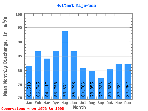
| Statistic | Jan | Feb | Mar | Apr | May | Jun | Jul | Aug | Sep | Oct | Nov | Dec | Annual |
|---|---|---|---|---|---|---|---|---|---|---|---|---|---|
| Mean | 81.52 | 86.75 | 84.12 | 86.80 | 93.67 | 86.75 | 80.79 | 79.95 | 77.23 | 80.34 | 82.28 | 82.25 | 83.54 |
| Standard Deviation | 19.70 | 21.20 | 21.39 | 17.83 | 18.39 | 13.37 | 12.18 | 13.19 | 13.96 | 14.53 | 17.82 | 18.86 | 12.23 |
| Min | 47.00 | 59.80 | 60.40 | 52.70 | 62.20 | 58.40 | 63.10 | 61.30 | 56.80 | 57.30 | 57.40 | 57.60 | 65.31 |
| Max | 146.00 | 148.00 | 148.00 | 142.00 | 149.00 | 124.00 | 107.00 | 122.00 | 112.00 | 115.00 | 136.00 | 155.00 | 106.81 |
| Coefficient of Variation | 0.24 | 0.24 | 0.25 | 0.20 | 0.20 | 0.15 | 0.15 | 0.17 | 0.18 | 0.18 | 0.22 | 0.23 | 0.15 |
 Return to R-Arctic Net Home Page