|
|
|||||||||||||||||
| Point ID: 7723 | Downloads | Plots | Site Data | Code: II007 |
|
|
|||||||||||||||||
| Download | |
|---|---|
| Site Descriptor Information | Site Time Series Data |
| Link to all available data | |
| View: | Time Series | All |
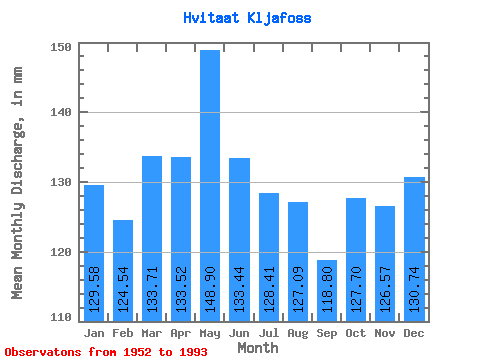
| Units: | m3/s |
| Statistic | Jan | Feb | Mar | Apr | May | Jun | Jul | Aug | Sep | Oct | Nov | Dec | Annual |
|---|---|---|---|---|---|---|---|---|---|---|---|---|---|
| Mean | 129.56 | 125.61 | 133.69 | 133.52 | 148.87 | 133.44 | 128.39 | 127.07 | 118.80 | 127.68 | 126.57 | 130.72 | 1564.63 |
| Standard Deviation | 31.31 | 30.71 | 34.00 | 27.43 | 29.23 | 20.57 | 19.36 | 20.96 | 21.47 | 23.09 | 27.41 | 29.98 | 229.00 |
| Min | 74.70 | 86.59 | 96.00 | 81.07 | 98.86 | 89.83 | 100.29 | 97.42 | 87.37 | 91.07 | 88.30 | 91.55 | 1223.22 |
| Max | 232.04 | 214.31 | 235.22 | 218.44 | 236.81 | 190.75 | 170.06 | 193.90 | 172.29 | 182.77 | 209.21 | 246.34 | 2000.52 |
| Coefficient of Variation | 0.24 | 0.24 | 0.25 | 0.20 | 0.20 | 0.15 | 0.15 | 0.17 | 0.18 | 0.18 | 0.22 | 0.23 | 0.15 |
 Return to R-Arctic Net Home Page