|
|
|||||||||||||||||
| Point ID: 7718 | Downloads | Plots | Site Data | Code: II002 |
|
|
|||||||||||||||||
| Download | |
|---|---|
| Site Descriptor Information | Site Time Series Data |
| Link to all available data | |
| View: | Time Series | All |
| Units: | mm |
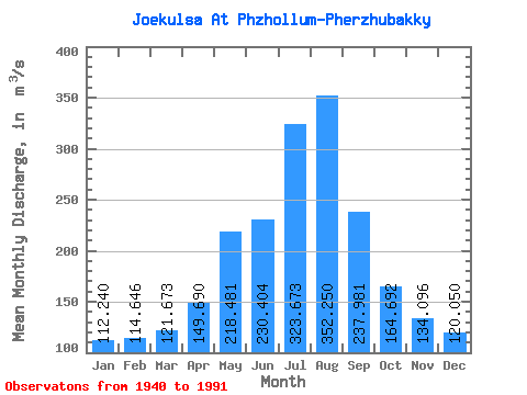
| Statistic | Jan | Feb | Mar | Apr | May | Jun | Jul | Aug | Sep | Oct | Nov | Dec | Annual |
|---|---|---|---|---|---|---|---|---|---|---|---|---|---|
| Mean | 112.24 | 114.65 | 121.67 | 149.69 | 218.48 | 230.40 | 323.67 | 352.25 | 237.98 | 164.69 | 134.10 | 120.05 | 189.99 |
| Standard Deviation | 16.10 | 25.46 | 26.25 | 40.06 | 56.10 | 67.07 | 78.67 | 105.12 | 53.18 | 26.97 | 18.14 | 18.31 | 24.73 |
| Min | 75.30 | 81.20 | 85.20 | 86.30 | 119.00 | 142.00 | 198.00 | 196.00 | 149.00 | 116.00 | 102.00 | 93.00 | 149.93 |
| Max | 150.00 | 252.00 | 219.00 | 269.00 | 369.00 | 463.00 | 633.00 | 665.00 | 377.00 | 262.00 | 180.00 | 168.00 | 273.42 |
| Coefficient of Variation | 0.14 | 0.22 | 0.22 | 0.27 | 0.26 | 0.29 | 0.24 | 0.30 | 0.22 | 0.16 | 0.14 | 0.15 | 0.13 |
 Return to R-Arctic Net Home Page