|
|
|||||||||||||||||
| Point ID: 7718 | Downloads | Plots | Site Data | Code: II002 |
|
|
|||||||||||||||||
| Download | |
|---|---|
| Site Descriptor Information | Site Time Series Data |
| Link to all available data | |
| View: | Time Series | All |
| Units: | m3/s |
| Statistic | Jan | Feb | Mar | Apr | May | Jun | Jul | Aug | Sep | Oct | Nov | Dec | Annual |
|---|---|---|---|---|---|---|---|---|---|---|---|---|---|
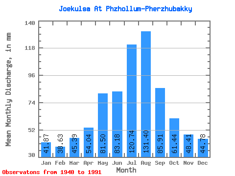
| Mean | 41.86 | 38.96 | 45.38 | 54.04 | 81.49 | 83.18 | 120.72 | 131.38 | 85.91 | 61.43 | 48.41 | 44.78 | 835.11 |
| Standard Deviation | 6.00 | 8.65 | 9.79 | 14.46 | 20.93 | 24.21 | 29.34 | 39.21 | 19.20 | 10.06 | 6.55 | 6.83 | 108.72 |
| Min | 28.09 | 27.59 | 31.78 | 31.16 | 44.38 | 51.26 | 73.85 | 73.10 | 53.79 | 43.27 | 36.82 | 34.69 | 659.04 |
| Max | 55.95 | 85.64 | 81.68 | 97.11 | 137.63 | 167.14 | 236.10 | 248.03 | 136.10 | 97.72 | 64.98 | 62.66 | 1201.82 |
| Coefficient of Variation | 0.14 | 0.22 | 0.22 | 0.27 | 0.26 | 0.29 | 0.24 | 0.30 | 0.22 | 0.16 | 0.14 | 0.15 | 0.13 |
 Return to R-Arctic Net Home Page