|
|
|||||||||||||||||
| Point ID: 7702 | Downloads | Plots | Site Data | Code: 15493700 |
|
|
|||||||||||||||||
| Download | |
|---|---|
| Site Descriptor Information | Site Time Series Data |
| Link to all available data | |
| View: | Time Series | All |
| Units: | mm |
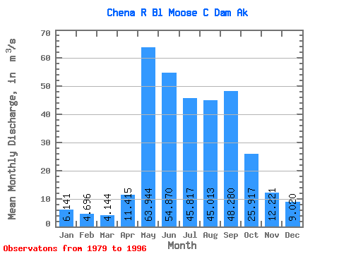
| Statistic | Jan | Feb | Mar | Apr | May | Jun | Jul | Aug | Sep | Oct | Nov | Dec | Annual |
|---|---|---|---|---|---|---|---|---|---|---|---|---|---|
| Mean | 6.14 | 4.70 | 4.14 | 11.41 | 63.94 | 54.87 | 45.82 | 45.01 | 48.28 | 25.92 | 12.22 | 9.02 | 28.29 |
| Standard Deviation | 2.05 | 1.92 | 1.59 | 8.12 | 32.46 | 27.15 | 19.60 | 14.85 | 28.86 | 13.16 | 4.72 | 3.55 | 6.30 |
| Min | 3.46 | 2.42 | 2.24 | 3.48 | 25.09 | 23.11 | 24.86 | 25.00 | 19.99 | 13.56 | 6.63 | 4.73 | 18.73 |
| Max | 9.66 | 8.66 | 6.94 | 26.14 | 152.91 | 131.47 | 94.04 | 77.76 | 108.08 | 51.11 | 23.14 | 17.56 | 38.48 |
| Coefficient of Variation | 0.33 | 0.41 | 0.38 | 0.71 | 0.51 | 0.49 | 0.43 | 0.33 | 0.60 | 0.51 | 0.39 | 0.39 | 0.22 |
 Return to R-Arctic Net Home Page