|
|
|||||||||||||||||
| Point ID: 7702 | Downloads | Plots | Site Data | Code: 15493700 |
|
|
|||||||||||||||||
| Download | |
|---|---|
| Site Descriptor Information | Site Time Series Data |
| Link to all available data | |
| View: | Time Series | All |
| Units: | m3/s |
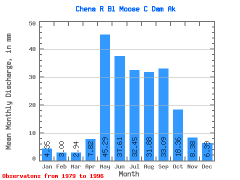
| Statistic | Jan | Feb | Mar | Apr | May | Jun | Jul | Aug | Sep | Oct | Nov | Dec | Annual |
|---|---|---|---|---|---|---|---|---|---|---|---|---|---|
| Mean | 4.35 | 3.03 | 2.94 | 7.83 | 45.29 | 37.61 | 32.45 | 31.88 | 33.09 | 18.35 | 8.38 | 6.39 | 236.09 |
| Standard Deviation | 1.45 | 1.24 | 1.12 | 5.56 | 22.99 | 18.61 | 13.88 | 10.52 | 19.79 | 9.32 | 3.24 | 2.52 | 52.58 |
| Min | 2.45 | 1.56 | 1.58 | 2.39 | 17.77 | 15.84 | 17.61 | 17.71 | 13.70 | 9.61 | 4.54 | 3.35 | 156.30 |
| Max | 6.84 | 5.59 | 4.91 | 17.92 | 108.29 | 90.12 | 66.60 | 55.07 | 74.09 | 36.20 | 15.86 | 12.43 | 321.14 |
| Coefficient of Variation | 0.33 | 0.41 | 0.38 | 0.71 | 0.51 | 0.49 | 0.43 | 0.33 | 0.60 | 0.51 | 0.39 | 0.39 | 0.22 |
 Return to R-Arctic Net Home Page