|
|
|||||||||||||||||
| Point ID: 7690 | Downloads | Plots | Site Data | Code: 15896000 |
|
|
|||||||||||||||||
| Download | |
|---|---|
| Site Descriptor Information | Site Time Series Data |
| Link to all available data | |
| View: | Time Series | All |
| Units: | mm |
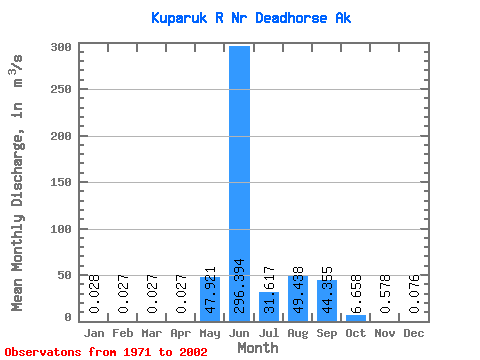
| Statistic | Jan | Feb | Mar | Apr | May | Jun | Jul | Aug | Sep | Oct | Nov | Dec | Annual |
|---|---|---|---|---|---|---|---|---|---|---|---|---|---|
| Mean | 0.03 | 0.03 | 0.03 | 0.03 | 47.92 | 296.39 | 31.62 | 49.44 | 44.35 | 6.66 | 0.58 | 0.08 | 39.11 |
| Standard Deviation | 0.09 | 0.09 | 0.09 | 0.09 | 69.29 | 152.88 | 20.39 | 43.38 | 32.35 | 4.75 | 0.95 | 0.15 | 11.64 |
| Min | 0.00 | 0.00 | 0.00 | 0.00 | 0.00 | 20.55 | 8.49 | 3.59 | 5.43 | 0.28 | 0.00 | 0.00 | 18.55 |
| Max | 0.28 | 0.28 | 0.28 | 0.28 | 251.38 | 745.99 | 89.75 | 148.06 | 137.69 | 19.58 | 4.92 | 0.69 | 65.84 |
| Coefficient of Variation | 3.02 | 3.09 | 3.11 | 3.11 | 1.45 | 0.52 | 0.65 | 0.88 | 0.73 | 0.71 | 1.64 | 2.03 | 0.30 |
 Return to R-Arctic Net Home Page