|
|
|||||||||||||||||
| Point ID: 7690 | Downloads | Plots | Site Data | Code: 15896000 |
|
|
|||||||||||||||||
| Download | |
|---|---|
| Site Descriptor Information | Site Time Series Data |
| Link to all available data | |
| View: | Time Series | All |
| Units: | m3/s |
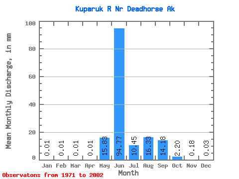
| Statistic | Jan | Feb | Mar | Apr | May | Jun | Jul | Aug | Sep | Oct | Nov | Dec | Annual |
|---|---|---|---|---|---|---|---|---|---|---|---|---|---|
| Mean | 0.01 | 0.01 | 0.01 | 0.01 | 15.83 | 94.77 | 10.44 | 16.33 | 14.18 | 2.20 | 0.18 | 0.03 | 152.24 |
| Standard Deviation | 0.03 | 0.03 | 0.03 | 0.03 | 22.89 | 48.88 | 6.74 | 14.33 | 10.35 | 1.57 | 0.30 | 0.05 | 45.33 |
| Min | 0.00 | 0.00 | 0.00 | 0.00 | 0.00 | 6.57 | 2.81 | 1.19 | 1.74 | 0.09 | 0.00 | 0.00 | 72.20 |
| Max | 0.09 | 0.09 | 0.09 | 0.09 | 83.04 | 238.52 | 29.65 | 48.91 | 44.03 | 6.47 | 1.57 | 0.23 | 256.31 |
| Coefficient of Variation | 3.02 | 3.09 | 3.11 | 3.11 | 1.45 | 0.52 | 0.65 | 0.88 | 0.73 | 0.71 | 1.64 | 2.03 | 0.30 |
 Return to R-Arctic Net Home Page