|
|
|||||||||||||||||
| Point ID: 7679 | Downloads | Plots | Site Data | Code: 15470000 |
|
|
|||||||||||||||||
| Download | |
|---|---|
| Site Descriptor Information | Site Time Series Data |
| Link to all available data | |
| View: | Time Series | All |
| Units: | mm |
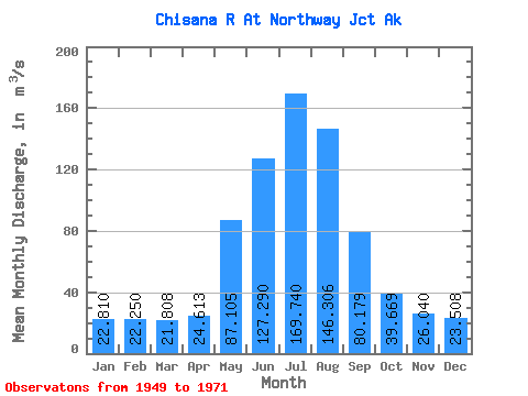
| Statistic | Jan | Feb | Mar | Apr | May | Jun | Jul | Aug | Sep | Oct | Nov | Dec | Annual |
|---|---|---|---|---|---|---|---|---|---|---|---|---|---|
| Mean | 22.81 | 22.25 | 21.81 | 24.61 | 87.11 | 127.29 | 169.74 | 146.31 | 80.18 | 39.67 | 26.04 | 23.51 | 65.85 |
| Standard Deviation | 3.47 | 2.79 | 2.79 | 3.13 | 27.09 | 44.65 | 26.05 | 30.14 | 17.15 | 7.56 | 3.66 | 3.31 | 10.10 |
| Min | 16.70 | 17.83 | 16.70 | 17.55 | 45.59 | 73.21 | 131.76 | 80.40 | 53.88 | 25.13 | 20.38 | 18.96 | 50.19 |
| Max | 29.57 | 27.73 | 27.73 | 29.63 | 141.67 | 230.42 | 233.13 | 227.65 | 115.41 | 54.39 | 35.86 | 31.64 | 92.51 |
| Coefficient of Variation | 0.15 | 0.12 | 0.13 | 0.13 | 0.31 | 0.35 | 0.15 | 0.21 | 0.21 | 0.19 | 0.14 | 0.14 | 0.15 |
 Return to R-Arctic Net Home Page