|
|
|||||||||||||||||
| Point ID: 7679 | Downloads | Plots | Site Data | Code: 15470000 |
|
|
|||||||||||||||||
| Download | |
|---|---|
| Site Descriptor Information | Site Time Series Data |
| Link to all available data | |
| View: | Time Series | All |
| Units: | m3/s |
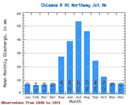
| Statistic | Jan | Feb | Mar | Apr | May | Jun | Jul | Aug | Sep | Oct | Nov | Dec | Annual |
|---|---|---|---|---|---|---|---|---|---|---|---|---|---|
| Mean | 7.19 | 6.39 | 6.88 | 7.51 | 27.46 | 38.84 | 53.51 | 46.12 | 24.46 | 12.51 | 7.95 | 7.41 | 244.62 |
| Standard Deviation | 1.09 | 0.80 | 0.88 | 0.95 | 8.54 | 13.62 | 8.21 | 9.50 | 5.23 | 2.38 | 1.12 | 1.04 | 37.52 |
| Min | 5.26 | 5.12 | 5.26 | 5.35 | 14.37 | 22.34 | 41.54 | 25.34 | 16.44 | 7.92 | 6.22 | 5.98 | 186.44 |
| Max | 9.32 | 7.97 | 8.74 | 9.04 | 44.66 | 70.30 | 73.49 | 71.76 | 35.21 | 17.15 | 10.94 | 9.97 | 343.68 |
| Coefficient of Variation | 0.15 | 0.12 | 0.13 | 0.13 | 0.31 | 0.35 | 0.15 | 0.21 | 0.21 | 0.19 | 0.14 | 0.14 | 0.15 |
 Return to R-Arctic Net Home Page