|
|
|||||||||||||||||
| Point ID: 7676 | Downloads | Plots | Site Data | Code: 71990 |
|
|
|||||||||||||||||
| Download | |
|---|---|
| Site Descriptor Information | Site Time Series Data |
| Link to all available data | |
| View: | Time Series | All |
| Units: | mm |
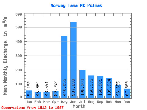
| Statistic | Jan | Feb | Mar | Apr | May | Jun | Jul | Aug | Sep | Oct | Nov | Dec | Annual |
|---|---|---|---|---|---|---|---|---|---|---|---|---|---|
| Mean | 54.19 | 46.96 | 43.59 | 50.09 | 440.06 | 537.70 | 198.20 | 160.38 | 158.90 | 139.92 | 96.66 | 67.87 | 166.54 |
| Standard Deviation | 7.71 | 6.07 | 5.17 | 17.28 | 214.00 | 267.15 | 90.00 | 69.81 | 74.26 | 48.65 | 26.65 | 12.13 | 30.21 |
| Min | 37.52 | 33.27 | 32.74 | 33.81 | 54.40 | 153.20 | 92.26 | 60.30 | 65.29 | 64.23 | 51.47 | 40.55 | 102.52 |
| Max | 79.81 | 63.86 | 59.98 | 145.93 | 1038.70 | 1377.80 | 613.25 | 407.36 | 443.78 | 381.52 | 188.62 | 114.90 | 268.66 |
| Coefficient of Variation | 0.14 | 0.13 | 0.12 | 0.34 | 0.49 | 0.50 | 0.45 | 0.43 | 0.47 | 0.35 | 0.28 | 0.18 | 0.18 |
 Return to R-Arctic Net Home Page