|
|
|||||||||||||||||
| Point ID: 7676 | Downloads | Plots | Site Data | Code: 71990 |
|
|
|||||||||||||||||
| Download | |
|---|---|
| Site Descriptor Information | Site Time Series Data |
| Link to all available data | |
| View: | Time Series | All |
| Units: | m3/s |
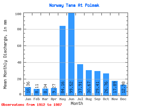
| Statistic | Jan | Feb | Mar | Apr | May | Jun | Jul | Aug | Sep | Oct | Nov | Dec | Annual |
|---|---|---|---|---|---|---|---|---|---|---|---|---|---|
| Mean | 10.36 | 8.18 | 8.34 | 9.27 | 84.15 | 99.52 | 37.90 | 30.67 | 29.41 | 26.76 | 17.89 | 12.98 | 375.29 |
| Standard Deviation | 1.47 | 1.06 | 0.99 | 3.20 | 40.92 | 49.44 | 17.21 | 13.35 | 13.74 | 9.30 | 4.93 | 2.32 | 68.08 |
| Min | 7.17 | 5.80 | 6.26 | 6.26 | 10.40 | 28.35 | 17.64 | 11.53 | 12.08 | 12.28 | 9.53 | 7.75 | 231.03 |
| Max | 15.26 | 11.13 | 11.47 | 27.01 | 198.62 | 255.00 | 117.26 | 77.89 | 82.13 | 72.95 | 34.91 | 21.97 | 605.42 |
| Coefficient of Variation | 0.14 | 0.13 | 0.12 | 0.34 | 0.49 | 0.50 | 0.45 | 0.43 | 0.47 | 0.35 | 0.28 | 0.18 | 0.18 |
 Return to R-Arctic Net Home Page