|
|
|||||||||||||||||
| Point ID: 7673 | Downloads | Plots | Site Data | Code: 7200 |
|
|
|||||||||||||||||
| Download | |
|---|---|
| Site Descriptor Information | Site Time Series Data |
| Link to all available data | |
| View: | Time Series | All |
| Units: | mm |
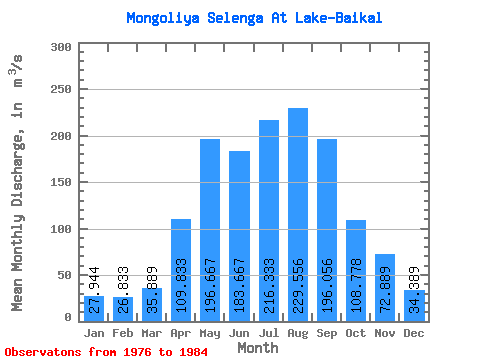
| Statistic | Jan | Feb | Mar | Apr | May | Jun | Jul | Aug | Sep | Oct | Nov | Dec | Annual |
|---|---|---|---|---|---|---|---|---|---|---|---|---|---|
| Mean | 27.94 | 26.83 | 35.89 | 109.83 | 196.67 | 183.67 | 216.33 | 229.56 | 196.06 | 108.78 | 72.89 | 34.39 | 119.90 |
| Standard Deviation | 4.23 | 4.74 | 7.59 | 35.77 | 88.38 | 79.78 | 118.24 | 140.63 | 159.55 | 24.74 | 37.98 | 5.08 | 38.53 |
| Min | 22.00 | 19.50 | 23.50 | 63.00 | 100.00 | 91.50 | 88.00 | 69.00 | 76.50 | 79.50 | 46.50 | 24.50 | 68.00 |
| Max | 34.00 | 32.50 | 43.50 | 171.00 | 415.00 | 321.00 | 397.00 | 543.00 | 592.00 | 152.00 | 166.00 | 39.00 | 195.04 |
| Coefficient of Variation | 0.15 | 0.18 | 0.21 | 0.33 | 0.45 | 0.43 | 0.55 | 0.61 | 0.81 | 0.23 | 0.52 | 0.15 | 0.32 |
 Return to R-Arctic Net Home Page