|
|
|||||||||||||||||
| Point ID: 7673 | Downloads | Plots | Site Data | Code: 7200 |
|
|
|||||||||||||||||
| Download | |
|---|---|
| Site Descriptor Information | Site Time Series Data |
| Link to all available data | |
| View: | Time Series | All |
| Units: | m3/s |
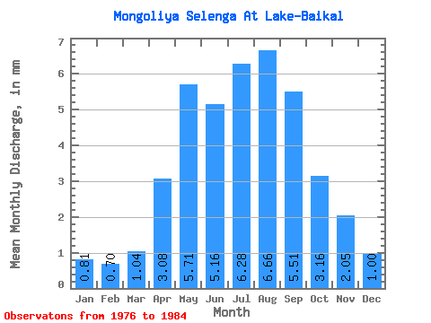
| Statistic | Jan | Feb | Mar | Apr | May | Jun | Jul | Aug | Sep | Oct | Nov | Dec | Annual |
|---|---|---|---|---|---|---|---|---|---|---|---|---|---|
| Mean | 0.81 | 0.71 | 1.04 | 3.08 | 5.71 | 5.16 | 6.28 | 6.66 | 5.51 | 3.16 | 2.05 | 1.00 | 41.00 |
| Standard Deviation | 0.12 | 0.12 | 0.22 | 1.00 | 2.56 | 2.24 | 3.43 | 4.08 | 4.48 | 0.72 | 1.07 | 0.15 | 13.18 |
| Min | 0.64 | 0.52 | 0.68 | 1.77 | 2.90 | 2.57 | 2.55 | 2.00 | 2.15 | 2.31 | 1.31 | 0.71 | 23.25 |
| Max | 0.99 | 0.86 | 1.26 | 4.80 | 12.04 | 9.01 | 11.52 | 15.76 | 16.62 | 4.41 | 4.66 | 1.13 | 66.69 |
| Coefficient of Variation | 0.15 | 0.18 | 0.21 | 0.33 | 0.45 | 0.43 | 0.55 | 0.61 | 0.81 | 0.23 | 0.52 | 0.15 | 0.32 |
 Return to R-Arctic Net Home Page