|
|
|||||||||||||||||
| Point ID: 7636 | Downloads | Plots | Site Data | Code: 71182 |
|
|
|||||||||||||||||
| Download | |
|---|---|
| Site Descriptor Information | Site Time Series Data |
| Link to all available data | |
| View: | Time Series | All |
| Units: | mm |
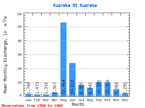
| Statistic | Jan | Feb | Mar | Apr | May | Jun | Jul | Aug | Sep | Oct | Nov | Dec | Annual |
|---|---|---|---|---|---|---|---|---|---|---|---|---|---|
| Mean | 1.75 | 1.47 | 1.32 | 2.91 | 52.96 | 24.01 | 8.36 | 6.04 | 10.39 | 10.16 | 5.07 | 2.29 | 10.89 |
| Standard Deviation | 0.53 | 0.40 | 0.36 | 3.92 | 38.24 | 24.28 | 7.11 | 6.42 | 8.30 | 6.78 | 4.30 | 1.07 | 5.82 |
| Min | 0.87 | 0.93 | 0.84 | 0.83 | 8.09 | 3.25 | 0.99 | 0.49 | 0.60 | 1.29 | 1.14 | 0.93 | 2.06 |
| Max | 2.93 | 2.47 | 2.39 | 20.70 | 115.00 | 101.00 | 25.50 | 31.00 | 28.90 | 23.10 | 18.90 | 5.76 | 21.67 |
| Coefficient of Variation | 0.30 | 0.27 | 0.28 | 1.35 | 0.72 | 1.01 | 0.85 | 1.06 | 0.80 | 0.67 | 0.85 | 0.47 | 0.53 |
 Return to R-Arctic Net Home Page