|
|
|||||||||||||||||
| Point ID: 7636 | Downloads | Plots | Site Data | Code: 71182 |
|
|
|||||||||||||||||
| Download | |
|---|---|
| Site Descriptor Information | Site Time Series Data |
| Link to all available data | |
| View: | Time Series | All |
| Units: | m3/s |
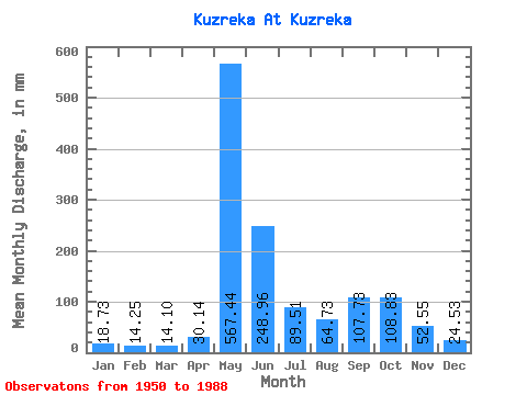
| Statistic | Jan | Feb | Mar | Apr | May | Jun | Jul | Aug | Sep | Oct | Nov | Dec | Annual |
|---|---|---|---|---|---|---|---|---|---|---|---|---|---|
| Mean | 18.73 | 14.37 | 14.10 | 30.14 | 567.35 | 248.95 | 89.50 | 64.72 | 107.73 | 108.81 | 52.55 | 24.53 | 1375.34 |
| Standard Deviation | 5.63 | 3.91 | 3.91 | 40.64 | 409.68 | 251.73 | 76.16 | 68.74 | 86.02 | 72.59 | 44.59 | 11.47 | 734.58 |
| Min | 9.32 | 9.07 | 9.05 | 8.59 | 86.66 | 33.70 | 10.66 | 5.26 | 6.21 | 13.82 | 11.82 | 9.96 | 260.44 |
| Max | 31.39 | 24.11 | 25.60 | 214.62 | 1231.88 | 1047.17 | 273.16 | 332.07 | 299.63 | 247.45 | 195.96 | 61.70 | 2735.09 |
| Coefficient of Variation | 0.30 | 0.27 | 0.28 | 1.35 | 0.72 | 1.01 | 0.85 | 1.06 | 0.80 | 0.67 | 0.85 | 0.47 | 0.53 |
 Return to R-Arctic Net Home Page