|
|
|||||||||||||||||
| Point ID: 7610 | Downloads | Plots | Site Data | Code: 71138 |
|
|
|||||||||||||||||
| Download | |
|---|---|
| Site Descriptor Information | Site Time Series Data |
| Link to all available data | |
| View: | Time Series | All |
| Units: | mm |
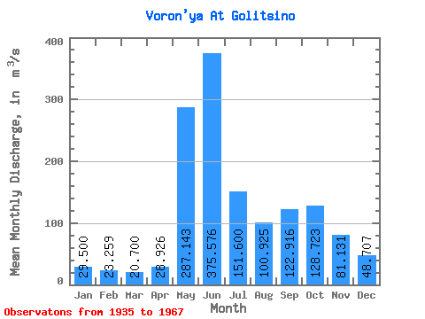
| Statistic | Jan | Feb | Mar | Apr | May | Jun | Jul | Aug | Sep | Oct | Nov | Dec | Annual |
|---|---|---|---|---|---|---|---|---|---|---|---|---|---|
| Mean | 29.50 | 23.26 | 20.70 | 28.93 | 287.14 | 375.58 | 151.60 | 100.92 | 122.92 | 128.72 | 81.13 | 48.71 | 117.32 |
| Standard Deviation | 8.01 | 6.61 | 6.14 | 20.47 | 139.55 | 177.67 | 59.30 | 31.94 | 39.95 | 39.49 | 24.51 | 16.08 | 22.43 |
| Min | 18.10 | 13.20 | 11.40 | 11.80 | 49.20 | 26.20 | 54.80 | 45.20 | 61.80 | 51.50 | 32.10 | 22.40 | 61.54 |
| Max | 43.40 | 36.30 | 32.90 | 99.00 | 578.00 | 773.00 | 351.00 | 172.00 | 242.00 | 201.00 | 127.00 | 73.60 | 153.13 |
| Coefficient of Variation | 0.27 | 0.28 | 0.30 | 0.71 | 0.49 | 0.47 | 0.39 | 0.32 | 0.33 | 0.31 | 0.30 | 0.33 | 0.19 |
 Return to R-Arctic Net Home Page