|
|
|||||||||||||||||
| Point ID: 7610 | Downloads | Plots | Site Data | Code: 71138 |
|
|
|||||||||||||||||
| Download | |
|---|---|
| Site Descriptor Information | Site Time Series Data |
| Link to all available data | |
| View: | Time Series | All |
| Units: | m3/s |
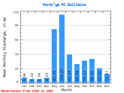
| Statistic | Jan | Feb | Mar | Apr | May | Jun | Jul | Aug | Sep | Oct | Nov | Dec | Annual |
|---|---|---|---|---|---|---|---|---|---|---|---|---|---|
| Mean | 8.46 | 6.08 | 5.94 | 8.03 | 82.33 | 104.23 | 43.47 | 28.94 | 34.11 | 36.91 | 22.52 | 13.96 | 396.44 |
| Standard Deviation | 2.30 | 1.73 | 1.76 | 5.68 | 40.01 | 49.31 | 17.00 | 9.16 | 11.09 | 11.32 | 6.80 | 4.61 | 75.78 |
| Min | 5.19 | 3.45 | 3.27 | 3.27 | 14.11 | 7.27 | 15.71 | 12.96 | 17.15 | 14.77 | 8.91 | 6.42 | 207.95 |
| Max | 12.44 | 9.48 | 9.43 | 27.47 | 165.73 | 214.52 | 100.64 | 49.32 | 67.16 | 57.63 | 35.24 | 21.10 | 517.44 |
| Coefficient of Variation | 0.27 | 0.28 | 0.30 | 0.71 | 0.49 | 0.47 | 0.39 | 0.32 | 0.33 | 0.31 | 0.30 | 0.33 | 0.19 |
 Return to R-Arctic Net Home Page