|
|
|||||||||||||||||
| Point ID: 7604 | Downloads | Plots | Site Data | Code: 71122 |
|
|
|||||||||||||||||
| Download | |
|---|---|
| Site Descriptor Information | Site Time Series Data |
| Link to all available data | |
| View: | Time Series | All |
| Units: | mm |
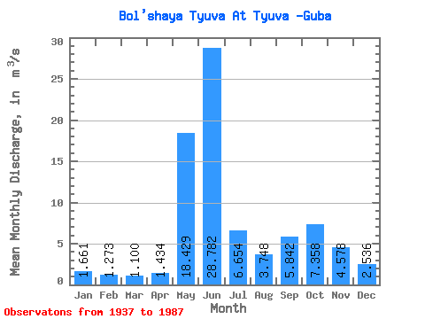
| Statistic | Jan | Feb | Mar | Apr | May | Jun | Jul | Aug | Sep | Oct | Nov | Dec | Annual |
|---|---|---|---|---|---|---|---|---|---|---|---|---|---|
| Mean | 1.66 | 1.27 | 1.10 | 1.43 | 18.43 | 28.78 | 6.65 | 3.75 | 5.84 | 7.36 | 4.58 | 2.54 | 7.09 |
| Standard Deviation | 0.44 | 0.31 | 0.30 | 0.98 | 12.27 | 12.86 | 3.90 | 2.26 | 3.05 | 3.15 | 1.75 | 0.80 | 1.31 |
| Min | 0.88 | 0.86 | 0.51 | 0.62 | 1.54 | 4.75 | 1.23 | 0.40 | 1.43 | 2.73 | 1.61 | 0.99 | 4.05 |
| Max | 3.13 | 2.14 | 1.89 | 6.01 | 61.90 | 52.90 | 17.60 | 9.33 | 18.80 | 14.80 | 9.74 | 4.83 | 10.29 |
| Coefficient of Variation | 0.27 | 0.24 | 0.27 | 0.68 | 0.67 | 0.45 | 0.59 | 0.60 | 0.52 | 0.43 | 0.38 | 0.32 | 0.18 |
 Return to R-Arctic Net Home Page