|
|
|||||||||||||||||
| Point ID: 7604 | Downloads | Plots | Site Data | Code: 71122 |
|
|
|||||||||||||||||
| Download | |
|---|---|
| Site Descriptor Information | Site Time Series Data |
| Link to all available data | |
| View: | Time Series | All |
| Units: | m3/s |
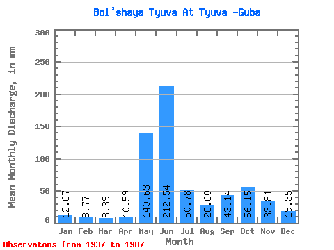
| Statistic | Jan | Feb | Mar | Apr | May | Jun | Jul | Aug | Sep | Oct | Nov | Dec | Annual |
|---|---|---|---|---|---|---|---|---|---|---|---|---|---|
| Mean | 12.67 | 8.85 | 8.39 | 10.59 | 140.60 | 212.54 | 50.77 | 28.59 | 43.14 | 56.14 | 33.80 | 19.35 | 637.19 |
| Standard Deviation | 3.36 | 2.13 | 2.26 | 7.21 | 93.59 | 94.95 | 29.77 | 17.22 | 22.52 | 24.06 | 12.96 | 6.11 | 117.60 |
| Min | 6.71 | 5.98 | 3.89 | 4.58 | 11.75 | 35.08 | 9.38 | 3.05 | 10.56 | 20.83 | 11.89 | 7.55 | 364.30 |
| Max | 23.88 | 14.88 | 14.42 | 44.38 | 472.27 | 390.65 | 134.28 | 71.18 | 138.83 | 112.92 | 71.93 | 36.85 | 924.77 |
| Coefficient of Variation | 0.27 | 0.24 | 0.27 | 0.68 | 0.67 | 0.45 | 0.59 | 0.60 | 0.52 | 0.43 | 0.38 | 0.32 | 0.18 |
 Return to R-Arctic Net Home Page