|
|
|||||||||||||||||
| Point ID: 7601 | Downloads | Plots | Site Data | Code: 71109 |
|
|
|||||||||||||||||
| Download | |
|---|---|
| Site Descriptor Information | Site Time Series Data |
| Link to all available data | |
| View: | Time Series | All |
| Units: | mm |
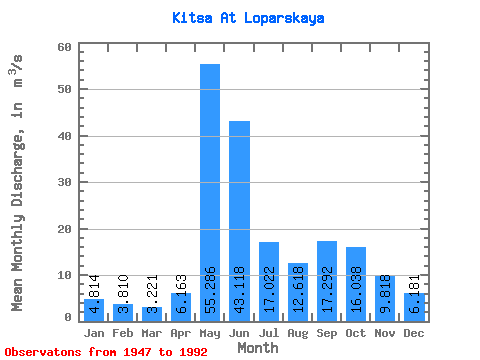
| Statistic | Jan | Feb | Mar | Apr | May | Jun | Jul | Aug | Sep | Oct | Nov | Dec | Annual |
|---|---|---|---|---|---|---|---|---|---|---|---|---|---|
| Mean | 4.81 | 3.81 | 3.22 | 6.16 | 55.29 | 43.12 | 17.02 | 12.62 | 17.29 | 16.04 | 9.82 | 6.18 | 16.30 |
| Standard Deviation | 1.08 | 0.87 | 0.66 | 6.37 | 25.02 | 22.71 | 10.09 | 6.00 | 7.72 | 5.77 | 3.97 | 1.31 | 3.10 |
| Min | 2.67 | 2.41 | 1.73 | 2.22 | 7.36 | 13.80 | 4.11 | 2.20 | 8.75 | 6.84 | 4.07 | 3.47 | 9.72 |
| Max | 8.27 | 6.60 | 4.95 | 31.40 | 111.00 | 104.00 | 45.10 | 25.40 | 52.50 | 32.10 | 25.40 | 9.25 | 24.61 |
| Coefficient of Variation | 0.22 | 0.23 | 0.20 | 1.03 | 0.45 | 0.53 | 0.59 | 0.48 | 0.45 | 0.36 | 0.40 | 0.21 | 0.19 |
 Return to R-Arctic Net Home Page