|
|
|||||||||||||||||
| Point ID: 7601 | Downloads | Plots | Site Data | Code: 71109 |
|
|
|||||||||||||||||
| Download | |
|---|---|
| Site Descriptor Information | Site Time Series Data |
| Link to all available data | |
| View: | Time Series | All |
| Units: | m3/s |
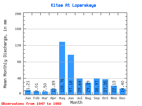
| Statistic | Jan | Feb | Mar | Apr | May | Jun | Jul | Aug | Sep | Oct | Nov | Dec | Annual |
|---|---|---|---|---|---|---|---|---|---|---|---|---|---|
| Mean | 11.21 | 8.08 | 7.50 | 13.89 | 128.74 | 97.18 | 39.64 | 29.38 | 38.98 | 37.35 | 22.13 | 14.39 | 447.35 |
| Standard Deviation | 2.51 | 1.84 | 1.54 | 14.35 | 58.26 | 51.19 | 23.50 | 13.98 | 17.40 | 13.44 | 8.95 | 3.06 | 85.19 |
| Min | 6.22 | 5.11 | 4.03 | 5.00 | 17.14 | 31.10 | 9.57 | 5.12 | 19.72 | 15.93 | 9.17 | 8.08 | 266.80 |
| Max | 19.26 | 14.00 | 11.53 | 70.77 | 258.49 | 234.41 | 105.02 | 59.15 | 118.33 | 74.75 | 57.25 | 21.54 | 675.29 |
| Coefficient of Variation | 0.22 | 0.23 | 0.20 | 1.03 | 0.45 | 0.53 | 0.59 | 0.48 | 0.45 | 0.36 | 0.40 | 0.21 | 0.19 |
 Return to R-Arctic Net Home Page