|
|
|||||||||||||||||
| Point ID: 7583 | Downloads | Plots | Site Data | Code: 71060 |
|
|
|||||||||||||||||
| Download | |
|---|---|
| Site Descriptor Information | Site Time Series Data |
| Link to all available data | |
| View: | Time Series | All |
| Units: | mm |
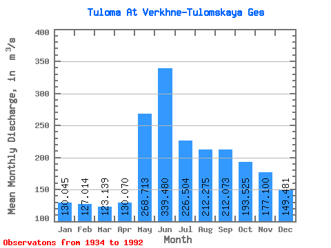
| Statistic | Jan | Feb | Mar | Apr | May | Jun | Jul | Aug | Sep | Oct | Nov | Dec | Annual |
|---|---|---|---|---|---|---|---|---|---|---|---|---|---|
| Mean | 130.04 | 127.01 | 123.14 | 130.07 | 268.71 | 339.48 | 226.50 | 212.28 | 212.07 | 193.53 | 177.10 | 149.48 | 192.23 |
| Standard Deviation | 58.56 | 71.20 | 74.53 | 70.41 | 196.45 | 200.66 | 108.58 | 98.07 | 82.69 | 61.88 | 58.59 | 60.25 | 35.02 |
| Min | 46.20 | 27.20 | 25.50 | 38.70 | 73.90 | 46.80 | 41.70 | 63.40 | 79.40 | 68.60 | 48.00 | 47.60 | 118.12 |
| Max | 246.00 | 286.00 | 305.00 | 262.00 | 844.00 | 816.00 | 568.00 | 509.00 | 419.00 | 382.00 | 295.00 | 267.00 | 264.36 |
| Coefficient of Variation | 0.45 | 0.56 | 0.60 | 0.54 | 0.73 | 0.59 | 0.48 | 0.46 | 0.39 | 0.32 | 0.33 | 0.40 | 0.18 |
 Return to R-Arctic Net Home Page