|
|
|||||||||||||||||
| Point ID: 7583 | Downloads | Plots | Site Data | Code: 71060 |
|
|
|||||||||||||||||
| Download | |
|---|---|
| Site Descriptor Information | Site Time Series Data |
| Link to all available data | |
| View: | Time Series | All |
| Units: | m3/s |
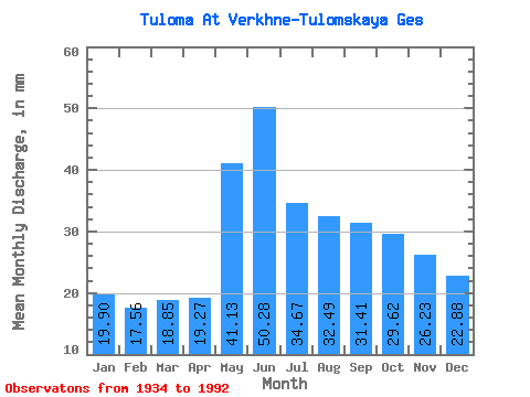
| Statistic | Jan | Feb | Mar | Apr | May | Jun | Jul | Aug | Sep | Oct | Nov | Dec | Annual |
|---|---|---|---|---|---|---|---|---|---|---|---|---|---|
| Mean | 19.90 | 17.71 | 18.84 | 19.27 | 41.12 | 50.28 | 34.66 | 32.48 | 31.41 | 29.61 | 26.23 | 22.88 | 346.68 |
| Standard Deviation | 8.96 | 9.93 | 11.40 | 10.43 | 30.06 | 29.72 | 16.62 | 15.01 | 12.25 | 9.47 | 8.68 | 9.22 | 63.16 |
| Min | 7.07 | 3.79 | 3.90 | 5.73 | 11.31 | 6.93 | 6.38 | 9.70 | 11.76 | 10.50 | 7.11 | 7.28 | 213.01 |
| Max | 37.65 | 39.88 | 46.67 | 38.81 | 129.16 | 120.86 | 86.92 | 77.89 | 62.06 | 58.46 | 43.69 | 40.86 | 476.75 |
| Coefficient of Variation | 0.45 | 0.56 | 0.60 | 0.54 | 0.73 | 0.59 | 0.48 | 0.46 | 0.39 | 0.32 | 0.33 | 0.40 | 0.18 |
 Return to R-Arctic Net Home Page