|
|
|||||||||||||||||
| Point ID: 7523 | Downloads | Plots | Site Data | Code: 70536 |
|
|
|||||||||||||||||
| Download | |
|---|---|
| Site Descriptor Information | Site Time Series Data |
| Link to all available data | |
| View: | Time Series | All |
| Units: | mm |
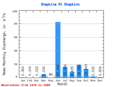
| Statistic | Jan | Feb | Mar | Apr | May | Jun | Jul | Aug | Sep | Oct | Nov | Dec | Annual |
|---|---|---|---|---|---|---|---|---|---|---|---|---|---|
| Mean | 0.36 | 0.10 | 0.02 | 5.23 | 82.44 | 15.94 | 8.63 | 18.89 | 13.05 | 2.03 | 0.83 | ||
| Standard Deviation | 36.35 | 6.95 | 8.50 | 14.64 | 9.22 | 0.92 | 0.36 | ||||||
| Min | 0.36 | 0.10 | 0.02 | 5.23 | 34.10 | 6.57 | 1.25 | 1.56 | 4.86 | 0.64 | 0.30 | ||
| Max | 0.36 | 0.10 | 0.02 | 5.23 | 126.00 | 32.40 | 27.60 | 51.00 | 30.10 | 3.30 | 1.25 | ||
| Coefficient of Variation | 0.44 | 0.44 | 0.98 | 0.78 | 0.71 | 0.45 | 0.43 |
 Return to R-Arctic Net Home Page