|
|
|||||||||||||||||
| Point ID: 7523 | Downloads | Plots | Site Data | Code: 70536 |
|
|
|||||||||||||||||
| Download | |
|---|---|
| Site Descriptor Information | Site Time Series Data |
| Link to all available data | |
| View: | Time Series | All |
| Units: | m3/s |
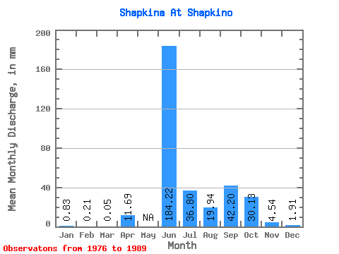
| Statistic | Jan | Feb | Mar | Apr | May | Jun | Jul | Aug | Sep | Oct | Nov | Dec | Annual |
|---|---|---|---|---|---|---|---|---|---|---|---|---|---|
| Mean | 0.83 | 0.21 | 0.05 | 11.69 | 184.22 | 36.79 | 19.93 | 42.20 | 30.12 | 4.54 | 1.91 | ||
| Standard Deviation | 81.23 | 16.05 | 19.61 | 32.72 | 21.30 | 2.05 | 0.83 | ||||||
| Min | 0.83 | 0.21 | 0.05 | 11.69 | 76.20 | 15.17 | 2.89 | 3.49 | 11.22 | 1.43 | 0.69 | ||
| Max | 0.83 | 0.21 | 0.05 | 11.69 | 281.55 | 74.80 | 63.72 | 113.96 | 69.49 | 7.37 | 2.89 | ||
| Coefficient of Variation | 0.44 | 0.44 | 0.98 | 0.78 | 0.71 | 0.45 | 0.43 |
 Return to R-Arctic Net Home Page