|
|
|||||||||||||||||
| Point ID: 752 | Downloads | Plots | Site Data | Code: 07GE002 |
|
|
|||||||||||||||||
| Download | |
|---|---|
| Site Descriptor Information | Site Time Series Data |
| Link to all available data | |
| View: | Time Series | All |
| Units: | mm |
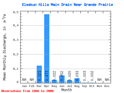
| Statistic | Jan | Feb | Mar | Apr | May | Jun | Jul | Aug | Sep | Oct | Nov | Dec | Annual |
|---|---|---|---|---|---|---|---|---|---|---|---|---|---|
| Mean | 0.12 | 0.48 | 0.02 | 0.05 | 0.02 | 0.03 | 0.00 | 0.00 | |||||
| Standard Deviation | 0.20 | 0.45 | 0.04 | 0.12 | 0.05 | 0.11 | 0.01 | 0.01 | |||||
| Min | 0.00 | 0.00 | 0.00 | 0.00 | 0.00 | 0.00 | 0.00 | 0.00 | |||||
| Max | 0.88 | 2.02 | 0.18 | 0.45 | 0.22 | 0.59 | 0.05 | 0.06 | |||||
| Coefficient of Variation | 1.69 | 0.95 | 1.91 | 2.34 | 2.52 | 3.40 | 3.11 | 5.09 |
 Return to R-Arctic Net Home Page