|
|
|||||||||||||||||
| Point ID: 752 | Downloads | Plots | Site Data | Code: 07GE002 |
|
|
|||||||||||||||||
| Download | |
|---|---|
| Site Descriptor Information | Site Time Series Data |
| Link to all available data | |
| View: | Time Series | All |
| Units: | m3/s |
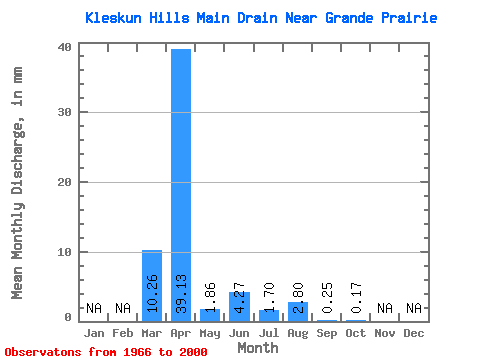
| Statistic | Jan | Feb | Mar | Apr | May | Jun | Jul | Aug | Sep | Oct | Nov | Dec | Annual |
|---|---|---|---|---|---|---|---|---|---|---|---|---|---|
| Mean | 10.27 | 39.12 | 1.86 | 4.29 | 1.69 | 2.80 | 0.24 | 0.16 | |||||
| Standard Deviation | 17.32 | 37.01 | 3.55 | 10.05 | 4.25 | 9.53 | 0.74 | 0.80 | |||||
| Min | 0.00 | 0.16 | 0.00 | 0.00 | 0.00 | 0.00 | 0.00 | 0.00 | |||||
| Max | 74.66 | 165.69 | 15.34 | 36.58 | 18.81 | 50.42 | 4.18 | 4.75 | |||||
| Coefficient of Variation | 1.69 | 0.95 | 1.91 | 2.34 | 2.52 | 3.40 | 3.11 | 5.09 |
 Return to R-Arctic Net Home Page