|
|
|||||||||||||||||
| Point ID: 7513 | Downloads | Plots | Site Data | Code: 70517 |
|
|
|||||||||||||||||
| Download | |
|---|---|
| Site Descriptor Information | Site Time Series Data |
| Link to all available data | |
| View: | Time Series | All |
| Units: | mm |
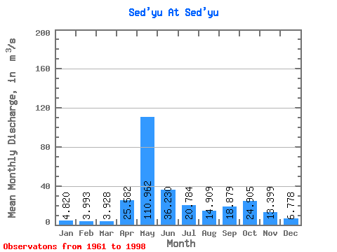
| Statistic | Jan | Feb | Mar | Apr | May | Jun | Jul | Aug | Sep | Oct | Nov | Dec | Annual |
|---|---|---|---|---|---|---|---|---|---|---|---|---|---|
| Mean | 4.82 | 3.99 | 3.93 | 25.58 | 110.96 | 36.23 | 20.78 | 14.91 | 18.88 | 24.91 | 13.40 | 6.78 | 23.80 |
| Standard Deviation | 1.11 | 0.86 | 0.66 | 30.97 | 34.55 | 19.40 | 14.66 | 11.99 | 7.25 | 12.08 | 6.12 | 2.26 | 4.01 |
| Min | 3.07 | 2.06 | 2.56 | 3.73 | 46.20 | 11.30 | 5.14 | 4.67 | 7.01 | 10.90 | 5.79 | 4.30 | 13.93 |
| Max | 8.02 | 6.16 | 5.26 | 122.00 | 176.00 | 86.60 | 63.60 | 67.30 | 38.20 | 69.40 | 27.50 | 16.30 | 31.82 |
| Coefficient of Variation | 0.23 | 0.22 | 0.17 | 1.21 | 0.31 | 0.54 | 0.70 | 0.80 | 0.38 | 0.48 | 0.46 | 0.33 | 0.17 |
 Return to R-Arctic Net Home Page