|
|
|||||||||||||||||
| Point ID: 7513 | Downloads | Plots | Site Data | Code: 70517 |
|
|
|||||||||||||||||
| Download | |
|---|---|
| Site Descriptor Information | Site Time Series Data |
| Link to all available data | |
| View: | Time Series | All |
| Units: | m3/s |
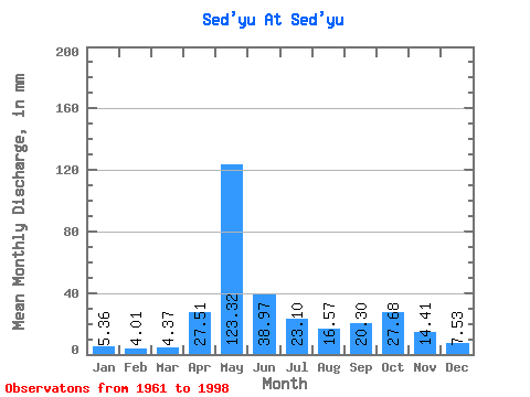
| Statistic | Jan | Feb | Mar | Apr | May | Jun | Jul | Aug | Sep | Oct | Nov | Dec | Annual |
|---|---|---|---|---|---|---|---|---|---|---|---|---|---|
| Mean | 5.36 | 4.04 | 4.36 | 27.51 | 123.30 | 38.97 | 23.09 | 16.57 | 20.30 | 27.68 | 14.41 | 7.53 | 311.61 |
| Standard Deviation | 1.23 | 0.87 | 0.73 | 33.30 | 38.39 | 20.87 | 16.29 | 13.32 | 7.79 | 13.43 | 6.58 | 2.51 | 52.47 |
| Min | 3.41 | 2.09 | 2.84 | 4.01 | 51.34 | 12.15 | 5.71 | 5.19 | 7.54 | 12.11 | 6.23 | 4.78 | 182.45 |
| Max | 8.91 | 6.24 | 5.84 | 131.21 | 195.57 | 93.14 | 70.67 | 74.78 | 41.09 | 77.12 | 29.58 | 18.11 | 416.73 |
| Coefficient of Variation | 0.23 | 0.22 | 0.17 | 1.21 | 0.31 | 0.54 | 0.70 | 0.80 | 0.38 | 0.48 | 0.46 | 0.33 | 0.17 |
 Return to R-Arctic Net Home Page