|
|
|||||||||||||||||
| Point ID: 7501 | Downloads | Plots | Site Data | Code: 70489 |
|
|
|||||||||||||||||
| Download | |
|---|---|
| Site Descriptor Information | Site Time Series Data |
| Link to all available data | |
| View: | Time Series | All |
| Units: | mm |
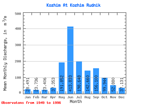
| Statistic | Jan | Feb | Mar | Apr | May | Jun | Jul | Aug | Sep | Oct | Nov | Dec | Annual |
|---|---|---|---|---|---|---|---|---|---|---|---|---|---|
| Mean | 28.49 | 23.74 | 23.41 | 37.35 | 191.85 | 413.83 | 198.65 | 142.66 | 156.10 | 99.94 | 52.88 | 37.13 | 117.58 |
| Standard Deviation | 7.37 | 6.37 | 6.65 | 32.59 | 116.63 | 140.89 | 71.24 | 42.19 | 46.83 | 32.30 | 19.74 | 10.57 | 16.42 |
| Min | 15.40 | 12.40 | 13.90 | 12.80 | 18.30 | 148.00 | 91.10 | 71.30 | 66.50 | 44.00 | 21.10 | 16.90 | 88.90 |
| Max | 48.00 | 38.70 | 44.70 | 180.00 | 484.00 | 722.00 | 433.00 | 257.00 | 295.00 | 185.00 | 110.00 | 67.40 | 161.24 |
| Coefficient of Variation | 0.26 | 0.27 | 0.28 | 0.87 | 0.61 | 0.34 | 0.36 | 0.30 | 0.30 | 0.32 | 0.37 | 0.28 | 0.14 |
 Return to R-Arctic Net Home Page