|
|
|||||||||||||||||
| Point ID: 7501 | Downloads | Plots | Site Data | Code: 70489 |
|
|
|||||||||||||||||
| Download | |
|---|---|
| Site Descriptor Information | Site Time Series Data |
| Link to all available data | |
| View: | Time Series | All |
| Units: | m3/s |
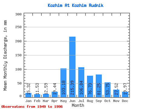
| Statistic | Jan | Feb | Mar | Apr | May | Jun | Jul | Aug | Sep | Oct | Nov | Dec | Annual |
|---|---|---|---|---|---|---|---|---|---|---|---|---|---|
| Mean | 15.32 | 11.63 | 12.59 | 19.44 | 103.17 | 215.39 | 106.82 | 76.72 | 81.25 | 53.74 | 27.52 | 19.97 | 745.14 |
| Standard Deviation | 3.96 | 3.12 | 3.58 | 16.96 | 62.72 | 73.33 | 38.31 | 22.69 | 24.37 | 17.37 | 10.27 | 5.68 | 104.08 |
| Min | 8.28 | 6.08 | 7.47 | 6.66 | 9.84 | 77.03 | 48.99 | 38.34 | 34.61 | 23.66 | 10.98 | 9.09 | 563.39 |
| Max | 25.81 | 18.96 | 24.04 | 93.69 | 260.27 | 375.79 | 232.85 | 138.20 | 153.54 | 99.48 | 57.25 | 36.24 | 1021.85 |
| Coefficient of Variation | 0.26 | 0.27 | 0.28 | 0.87 | 0.61 | 0.34 | 0.36 | 0.30 | 0.30 | 0.32 | 0.37 | 0.28 | 0.14 |
 Return to R-Arctic Net Home Page