|
|
|||||||||||||||||
| Point ID: 7494 | Downloads | Plots | Site Data | Code: 70458 |
|
|
|||||||||||||||||
| Download | |
|---|---|
| Site Descriptor Information | Site Time Series Data |
| Link to all available data | |
| View: | Time Series | All |
| Units: | mm |
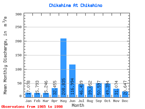
| Statistic | Jan | Feb | Mar | Apr | May | Jun | Jul | Aug | Sep | Oct | Nov | Dec | Annual |
|---|---|---|---|---|---|---|---|---|---|---|---|---|---|
| Mean | 17.08 | 15.79 | 15.25 | 32.45 | 208.84 | 116.99 | 46.44 | 39.05 | 50.60 | 49.39 | 31.07 | 20.65 | 53.09 |
| Standard Deviation | 3.35 | 3.89 | 3.33 | 36.59 | 72.75 | 73.68 | 19.82 | 23.72 | 19.80 | 17.79 | 9.57 | 3.95 | 8.02 |
| Min | 8.02 | 4.59 | 5.14 | 10.10 | 49.50 | 33.80 | 21.20 | 16.90 | 22.30 | 20.50 | 13.70 | 12.60 | 36.74 |
| Max | 23.30 | 26.20 | 21.50 | 200.00 | 296.00 | 385.00 | 105.00 | 122.00 | 88.60 | 99.80 | 50.90 | 32.40 | 74.80 |
| Coefficient of Variation | 0.20 | 0.25 | 0.22 | 1.13 | 0.35 | 0.63 | 0.43 | 0.61 | 0.39 | 0.36 | 0.31 | 0.19 | 0.15 |
 Return to R-Arctic Net Home Page