|
|
|||||||||||||||||
| Point ID: 7494 | Downloads | Plots | Site Data | Code: 70458 |
|
|
|||||||||||||||||
| Download | |
|---|---|
| Site Descriptor Information | Site Time Series Data |
| Link to all available data | |
| View: | Time Series | All |
| Units: | m3/s |
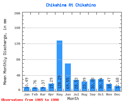
| Statistic | Jan | Feb | Mar | Apr | May | Jun | Jul | Aug | Sep | Oct | Nov | Dec | Annual |
|---|---|---|---|---|---|---|---|---|---|---|---|---|---|
| Mean | 10.49 | 8.84 | 9.37 | 19.29 | 128.27 | 69.55 | 28.52 | 23.99 | 30.08 | 30.34 | 18.47 | 12.68 | 384.33 |
| Standard Deviation | 2.06 | 2.18 | 2.04 | 21.76 | 44.69 | 43.80 | 12.17 | 14.57 | 11.77 | 10.93 | 5.69 | 2.42 | 58.04 |
| Min | 4.93 | 2.57 | 3.16 | 6.00 | 30.40 | 20.09 | 13.02 | 10.38 | 13.26 | 12.59 | 8.14 | 7.74 | 265.96 |
| Max | 14.31 | 14.66 | 13.21 | 118.90 | 181.81 | 228.88 | 64.49 | 74.94 | 52.67 | 61.30 | 30.26 | 19.90 | 541.44 |
| Coefficient of Variation | 0.20 | 0.25 | 0.22 | 1.13 | 0.35 | 0.63 | 0.43 | 0.61 | 0.39 | 0.36 | 0.31 | 0.19 | 0.15 |
 Return to R-Arctic Net Home Page