|
|
|||||||||||||||||
| Point ID: 7484 | Downloads | Plots | Site Data | Code: 70429 |
|
|
|||||||||||||||||
| Download | |
|---|---|
| Site Descriptor Information | Site Time Series Data |
| Link to all available data | |
| View: | Time Series | All |
| Units: | mm |
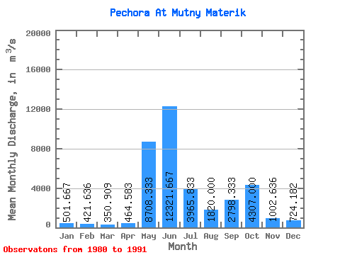
| Statistic | Jan | Feb | Mar | Apr | May | Jun | Jul | Aug | Sep | Oct | Nov | Dec | Annual |
|---|---|---|---|---|---|---|---|---|---|---|---|---|---|
| Mean | 501.67 | 421.64 | 350.91 | 464.58 | 8708.33 | 12321.67 | 3965.83 | 1820.00 | 2798.33 | 4307.00 | 1002.64 | 724.18 | 3146.20 |
| Standard Deviation | 98.03 | 102.39 | 76.06 | 272.20 | 4097.62 | 4131.43 | 1260.83 | 603.85 | 1196.02 | 6629.53 | 322.92 | 154.81 | 583.54 |
| Min | 404.00 | 298.00 | 243.00 | 251.00 | 2650.00 | 6600.00 | 2340.00 | 1050.00 | 1050.00 | 1100.00 | 651.00 | 550.00 | 2620.25 |
| Max | 703.00 | 587.00 | 469.00 | 1240.00 | 16800.00 | 20100.00 | 6280.00 | 3040.00 | 4390.00 | 22900.00 | 1790.00 | 1020.00 | 4334.17 |
| Coefficient of Variation | 0.20 | 0.24 | 0.22 | 0.59 | 0.47 | 0.34 | 0.32 | 0.33 | 0.43 | 1.54 | 0.32 | 0.21 | 0.18 |
 Return to R-Arctic Net Home Page